
Earthquake Early Warning - Blog
2026-06-18: Earthquake shakes southern Quebec
On the morning of June 18th, a magnitude 4.5 earthquake occurred in the Lower Saint Lawrence, shaking communities from east of Sept-Iles to Quebec City, and on to Ottawa. Felt shaking also extended into New Brunswick and on Prince Edward Island. While far-reaching, the shaking from this event was relatively light and resulted in no reports of damage.
![map of earthquake’s epicentre (star) and EEW warning times (concentric dashed circles)]](/images/eew/202606MontJoli-map-En.png)
The earthquake early warning system detected the event and generated an alert for technical partners in the area. Had the earthquake been larger (at least magnitude 5) and expected to cause stronger shaking, the earthquake early warning system would have sent alerts to the public, via the National Public Alerting System. Baie-Comeau and Port-Cartier would have received approximately 20 seconds of warning, Saguenay 40 seconds, Quebec City 70 seconds, Fredericton 80 seconds, Montreal 140 seconds, and Ottawa 170 seconds. Baie Comeau, Rimouski, and other towns very close to the earthquake’s epicentre are within the earthquake’s late alert zone, where it would not be possible to receive a warning before the onset of strong shaking.
2026-05-14: EEW documentary
A new documentary short film was produced by BC’s Ministry of Citizen Services in collaboration with Natural Resources Canada and the Strathcona Regional District. It spotlights Canada’s Earthquake Early Warning system operating in BC, where a network of nearly 200 specialised seismometers is able to detect the various types of earthquakes that occur throughout the region - providing seconds to tens of seconds of warning before strong shaking arrives
The film also profiles the Connected Coast network of fibre optic cables installed along the challenging geography of British Columbia’s coastlines. The Connected Coast network strengthens the resilience and effectiveness of the EEW system through an alternative form of communications, helping to ensure EEW reaches people, infrastructure, and emergency services in remote communities.
2026-04-14: M3.9 earthquake shakes parts of Quebec and Ontario
On Tuesday, 14th April, a magnitude 3.9 earthquake occurred near Ladysmith, Quebec, within a region known as the Western Quebec Seismic Zone. Shaking was reported by people in southwestern Quebec and eastern Ontario - as far as Montreal and Quebec City, in Quebec, and Toronto and London, in Ontario.
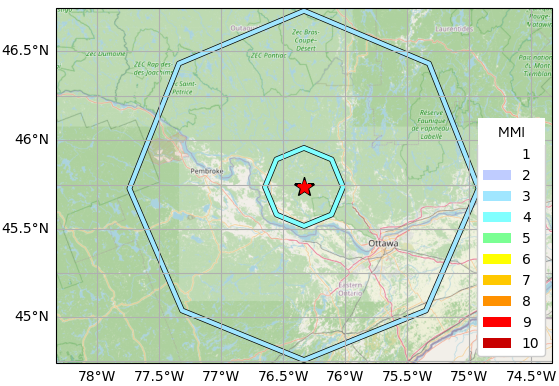
The national Earthquake Early Warning (EEW) system detected the earthquake and analysed it effectively, determining that an area within about 30km of the epicentre would likely experience shaking at an intensity (MMI) of IV, and to distances of about 110 km at an intensity of III.
People are sent EEW via the National Public Alerting System for earthquakes of magnitude 5 and above, and intensity IV and above. Technical Partners are notified at slightly lower thresholds: magnitude 4 and intensity III. Technical Partners are usually critical infrastructure operators who have systems in place to initiate automated protective actions, such as to open doors, stop trains, close valves, and sound alarms. Due to its relatively low magnitude, no EEW was sent for this earthquake.
This event occurred close to the location of the M5.3 earthquake which shook the region in 2013. Had the EEW system been operational in 2013, EEW would have been sent to Technical Partners.
2026-03-16: Earthquakes Canada webpages updated
Natural Resources Canada has launched an introductory version of its redesigned significant event webpages, designed to provide more comprehensive earthquake information in a highly accessible format. The update introduces interactive maps of historical regional earthquakes, community intensity reports, and data from nearby monitoring stations. In addition, to further enhance public safety and awareness, ShakeMaps show the strength of ground shaking across different areas and provide specific details on earthquake ruptures. To ensure a smooth transition for technical users, the old and new versions of the pages will be available in parallel for a limited time.
2026-02-28: 25 years since Nisqually earthquake
Twenty-five years ago, the region around Olympia and Seattle in Washington State, and Victoria and Vancouver in British Columbia, were shaken by a magnitude 6.8 earthquake. The event occurred at a depth of 52km, within the Juan de Fuca Plate, beneath the North American Plate. Shaking caused damage to older masonry buildings in the vicinity of Olympia and Seattle, broke windows at the Seattle-Tacoma Airport, and damaged roadways. In Victoria, light shaking toppled items from shelves and produced minor cracks in drywall and old pipes. Had the earthquake been shallower, the damage would have been considerably worse; the earthquake would have been closer to surface and the infrastructure, and the shaking would have been stronger.
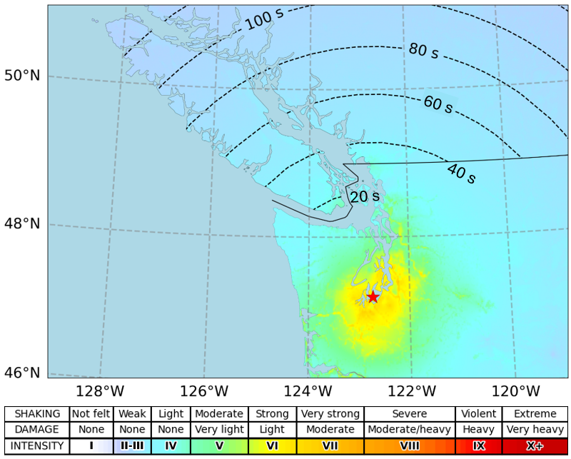
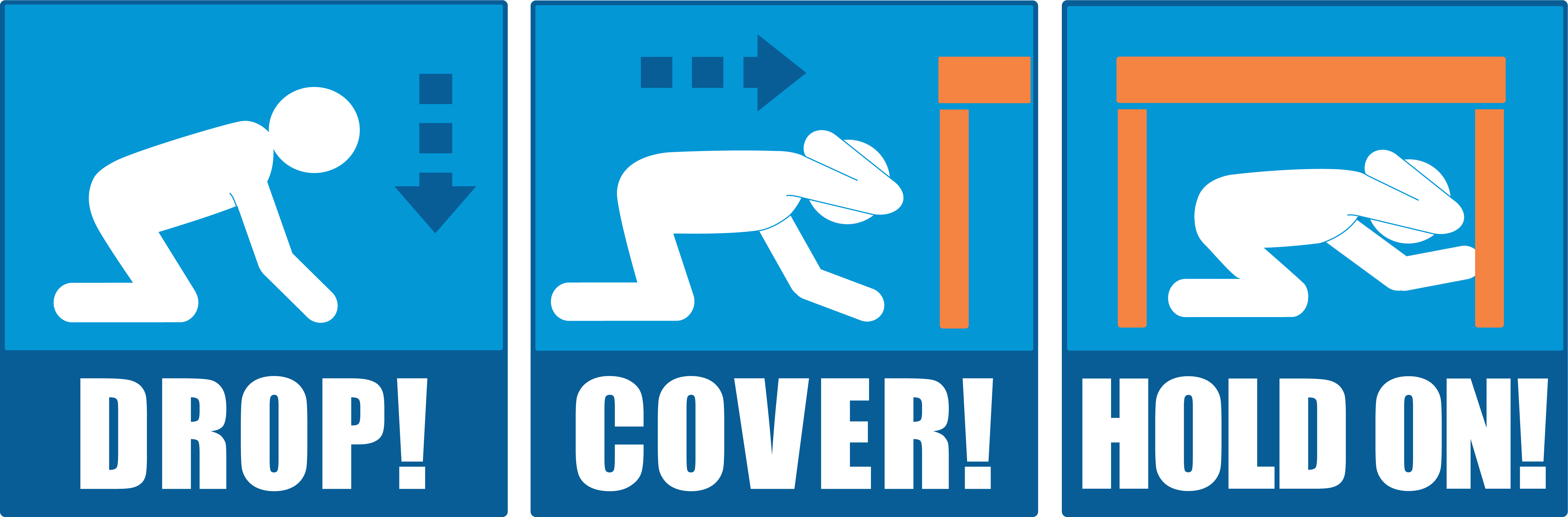
Had the Earthquake Early Warning system been operational at that time, Victoria would have received approximately 20 seconds of warning and Vancouver 30 seconds. This provides time for people to protect themselves - to drop, cover, and hold on. Gradually, critical infrastructure operators and other Technical Partners of the EEW system will be able to trigger automated technologies at their facilities, for example, to open doors, close valves, stop trains, and sound alarms.
2025-12-01: Earthquake Early Warning presented at Building Resilient Communities conference
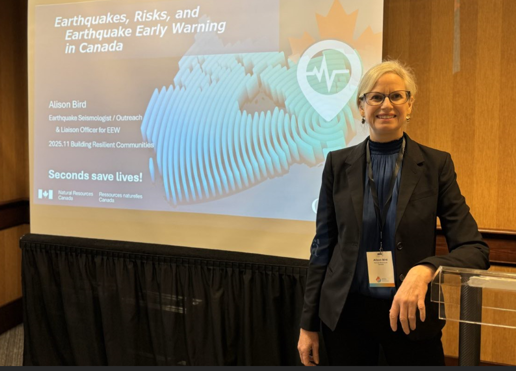
Last week, NRCan earthquake seismologist, Alison Bird, attended the Building Resilient Communities conference in Penticton, BC. The conference brings together emergency managers and planners from local governments, First Nations, and other organizations, plus critical infrastructure operators. This was an ideal venue for Bird to present Canada’s earthquakes, associated hazards, and earthquake early warning system. She participated in numerous fruitful discussions on natural hazards and ways to be resilient, including early warnings. By sharing experiences, best practices, and emerging technologies, Canada’s communities are able to improve their resilience to earthquakes, wildfires, floods, landslides, and severe weather events.
2025-11-27: Launch of eastern EEW system
Today, Natural Resources Canada initiated the eastern segment of the national Earthquake Early Warning system, for high-risk regions of Ontario and Quebec. Over 200 EEW stations are working together to monitor and alert for powerful earthquakes in the provinces, providing seconds to tens-of-seconds of warning before the arrival of strong shaking. People will be alerted through the National Public Alerting System, via smart-phone, radio, and television; this is fully automatic and requires no registration nor app. When an EEW is received, people should immediately protect themselves - drop, cover, and hold on. In the future, critical infrastructure operators and other Technical Partners of the EEW system will be able to trigger automated technologies at their facilities, for example, to open doors, close valves, stop trains, and sound alarms.
2025-10-16: ShakeOut / GrandeSecousse earthquake drill held in Canada
On Thursday, 16th October, approximately 60 million people around the world practised the Drop, Cover, Hold on response, in case of an earthquake. In Canada, over 865,000 people participated in this annual drill. They are therefore more likely to protect themselves when they receive an Earthquake Early Warning (EEW) or feel shaking.
In Quebec and Ontario, ShakeOut (Grande Sécousse) drills were held in numerous primary schools, Grande Secousse was promoted via social media platforms, and informational segments were given by one of NRCan’s eastern seismologists, on radio and television stations throughout the day – using this as an opportunity to promote the EEW system which will soon be launched in Quebec and eastern Ontario.
The same seismologist also delivered a webinar for municipal coordinators on seismic risk, la Grande Sécousse, and EEW, plus conducted a workshop on the same topics to municipalities and organisations throughout the Montréal Metropolitan area. Additionally, paleoseismologist Aube Gourdeau was filmed for a series of Informational videos on seismic risk and la Grande Sécousse.
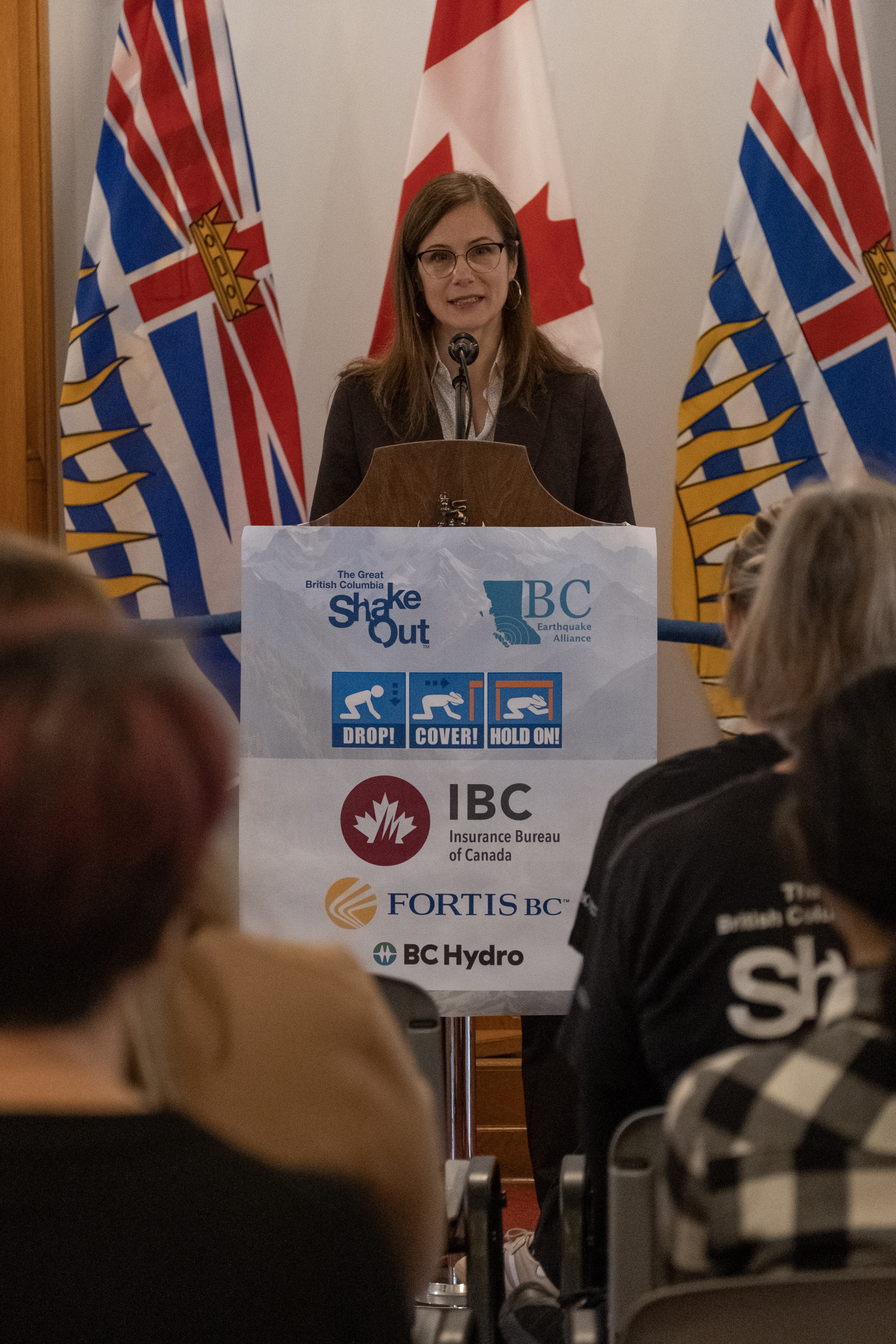
In British Columbia, the earthquake drill was hosted by the Provincial Legislative Assembly, and conducted throughout BC’s Parliamentary Buildings, by staff and visitors. The associated media event was emceed by BC Earthquake Alliance Vice President, and included a welcome by an Indigenous Counsellor from the Songhees Nation, and a speech by the Minister for Emergency Management and Climate Readiness for the province. A representative from the Insurance Bureau of Canada, spoke about the need for people and businesses to prepare for the earthquakes which would inevitably affect the province. Finally, one of NRCan’s western seismologists provided an overview of the EEW system. The day’s event was preceded, the evening before, by a public “Ask-the-Experts” webinar on earthquakes, associated hazards, and EEW.
In the Yukon, the Yukon Government promoted earthquake awareness and the Drop, Cover, Hold on response via social media and an information bulletin.
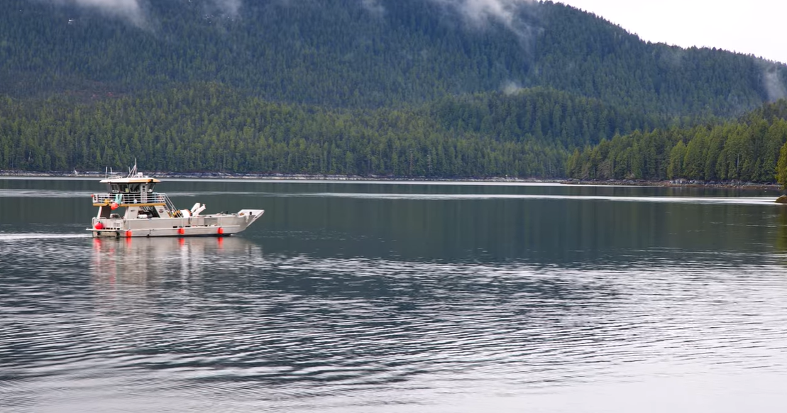
2025-09-22: Fieldwork in the Campbell River area
For three days last week, one of NRCan’s seismologists assisted a field technologist to service five earthquake monitoring stations on Vancouver Island, at Chemainus, Campbell River, Elk Falls, Gold River, and Myra Falls in Strathcona Park. Repairs and maintenance like this help to ensure the reliable, continuous operation of NRCan’s seismic and GNSS (global navigation satellite system) networks to monitor, alert (as part of the national Earthquake Early Warning system), and research earthquakes.
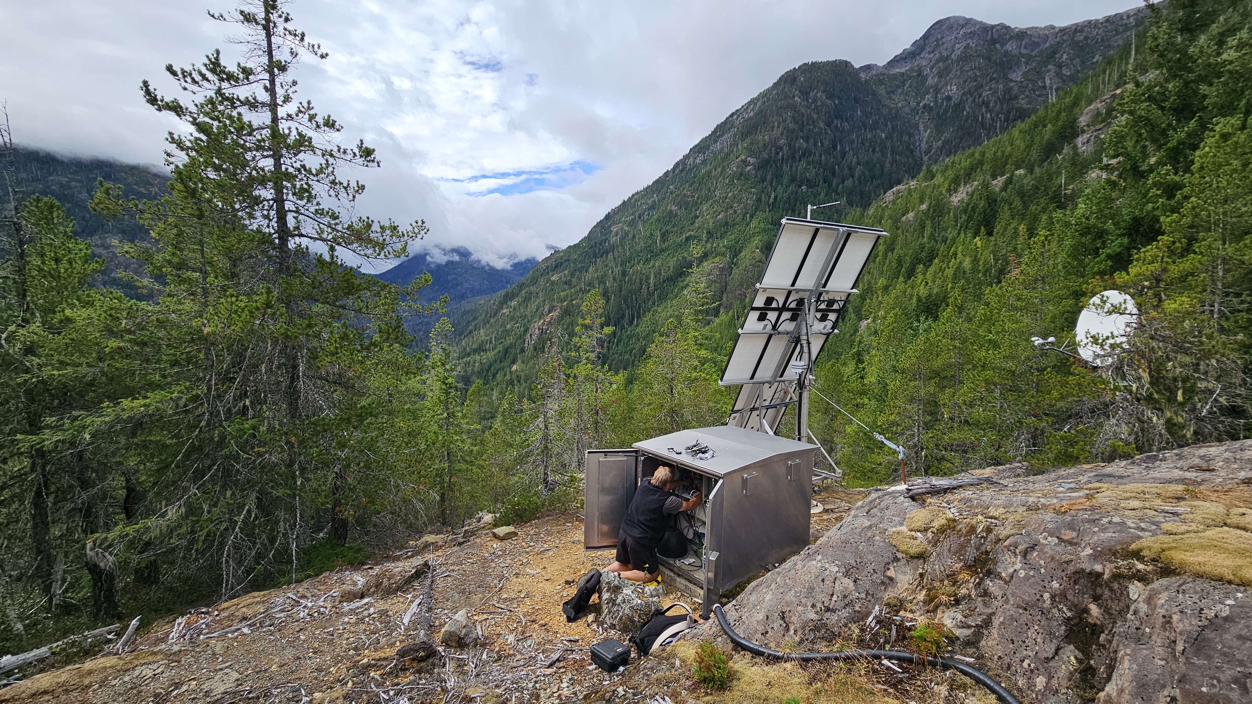
Many of NRCan’s stations are located in rugged and coastal terrains, requiring slow drives along rough roads, hiking, and, occasionally, helicopter or boat travel to access them. Fieldwork also takes place in Canada’s myriad of weathers, which can pose additional challenges. At the last station, near Myra Falls Mine, the duo were therefore relieved the weather was dry as they replaced the station’s GNSS monitoring equipment.
The fieldwork often gets supported by collaborator organisations; in this case, the crew were grateful for the assistance of staff at Myra Falls Mine, RCMP, BC Ferries, and West Coast Marine Terminal (Gold River).